Drainage
Hydraulic Design Training Progression (Flowchart)
Recommended Drainage Help Videos
Watershed Modeling System (WMS)
WMS Helpful links that include General knowledge, hydrology modeling, 2D hydraulic modeling and applications.
Important Note
“If you download and install the latest update and your software maintenance has expired, you will not be able to run WMS. Please make sure your WMS maintenance license has not expired before downloading. You can determine your maintenance expiration date by selecting the Help | Register command from WMS. You can renew your maintenance by visiting Aquaveo's web page or by contacting a sales representative. Prices and other information about renewing your license are available on the WMS Pricing Page. The latest update to WMS can be downloaded here.”
WMS 11.3.1 - November 12, 2024
Undefined
- 15335 WMS .ini file is affecting different versions of WMS
- 15373 "Reproject Rasters" Tool Converts Units Incorrectly
Projection
- 15329 WMS issue with GIS data
- 15330 Projection is not being changed back to default when closing and relaunching WMS
Highway Lighting
MoDOT Engineering Policy Guide (EPG) Section 901- Lighting
DIALux Lighting Software Information
DIALux Vendor Roadway Lighting Design YouTube Playlist
DIALux Zip archive with MoDOT's Standard IES files
OpenRoads ConceptStation
Bentley Communities ConceptStation Support Page
OpenRoads Designer
Bridge Survey Tools
Bridge Survey Profiles (Video)
HEC-RAS Converter for ORD (YouTube Playlist)
HEC-RAS Converter Spreadsheet for ORD (Spreadsheet)
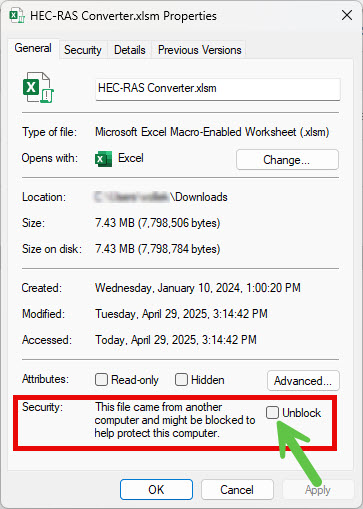
After downloading HEC_RAS Converter Spreadsheet, right-click on the file and select Properties
Within the Security area of the dialog select "Unblock"
After unblocking, the spreadsheet will have access to the built in Macros.
Also, place HEC_RAS Converter Spreadsheet in non-OneDrive location. (The spreadsheet automatically makes a backup of itself when run, OneDrive locations impede that process.
MicroStation
Levels
Miscellaneous Items
Assigning Key-In Commands to Function (F1-F12) Keys
Changing Angle Readout from Decimal Degree to Degree/Minute/Second
Deleting Duplicate Elements and Compressing Files
Quantab
Adding Rows for Quantity Blocks in Quantab
Special Characters in the Quantab Sheet
System and Administrative Procedures
Technical Recommendations For PW/CADD Users Working From Home
Roadway Design Help files and Videos
Cross Sections - End Area Volumes (Video)
Cross Sections - Overview (Video)
Dynamic Cross Sections (Video)
Level Management for Plan Sheets, Plan-Profile Sheets, and Profile Sheets (Video)
MoDOT Superelevation Explained (Video)
ProjectWise
Contract Plans Information
File Naming Convention for Contract Plan Drawings - EPG 237.13
Preparing MicroStation Files for Create Renditions Application (ProjectWise Manual Page 4-1)
Guidelines for Addendums or Revision Sheets
File Naming Convention for Addendums or Revision Sheets - EPG 237.9.4
Identification of Revisions in Addendums
Miscellaneous Information
Cleaning up the ProjectWise Organizer
Reattaching Reference Files using Scan References
Signing and Sealing
Step 1: Creating Digital ID Folder Setup
Step 2: Creating Digital ID Signature for Adobe Reader
Step 3: Digitally Signing PDF Files
Reassociating PDF Seal and Digital ID to Adobe Reader DC
Consultant Signing and Sealing
State Statue for Sealing Documents
Geometrics Design Series Training
Geometric Design Training Project - Lesson Flowchart
Geometrics Design - Part 1 (Basic Series)
Geometrics Design - Part 2a (Horizontal Alignment Series)
Geometrics Design - Part 2b (Vertical Alignment Series)
Geometrics Design - Part 2c (Quantities Series)
Geometrics Design - Part 3 (Intersection Series)
Geometrics Design - Part 4 (Clear Zone Series)
Survey
Survey Code List (Topcon) - Note: Download Zip file and extract MXL file.
Survey Code List (Trimble) - Note: Download Zip file and extract FXL file.
2022 State Plane Coordinate System Zone Codes
Do I have a Chord or Arc Defined Curve? (Spreadsheet)
Best Practices in GNSS Surveying
Topcon MAGNET Field Training 2024 PowerPoint
Other Applications
Interactive Highway Safety Design Model
|
The Interactive Highway Safety Design Model or IHSDM is a suite of software analysis tools for evaluating safety and operational effects of geometric design decisions on highways. The software is developed and distributed by the Federal Highway Administration and user support is also offered through that agency. |
AQCESSRAMP
| Transoft, the company that produces AutoTurn has a new version of their AQCESSRAMP software. MoDOT does not have any licenses of this software. Here is a short video demonstration. Does anyone have any interest in learning more? Contact caddsupport@modot.mo.gov |


