Districts Impacted
Why is this project needed?
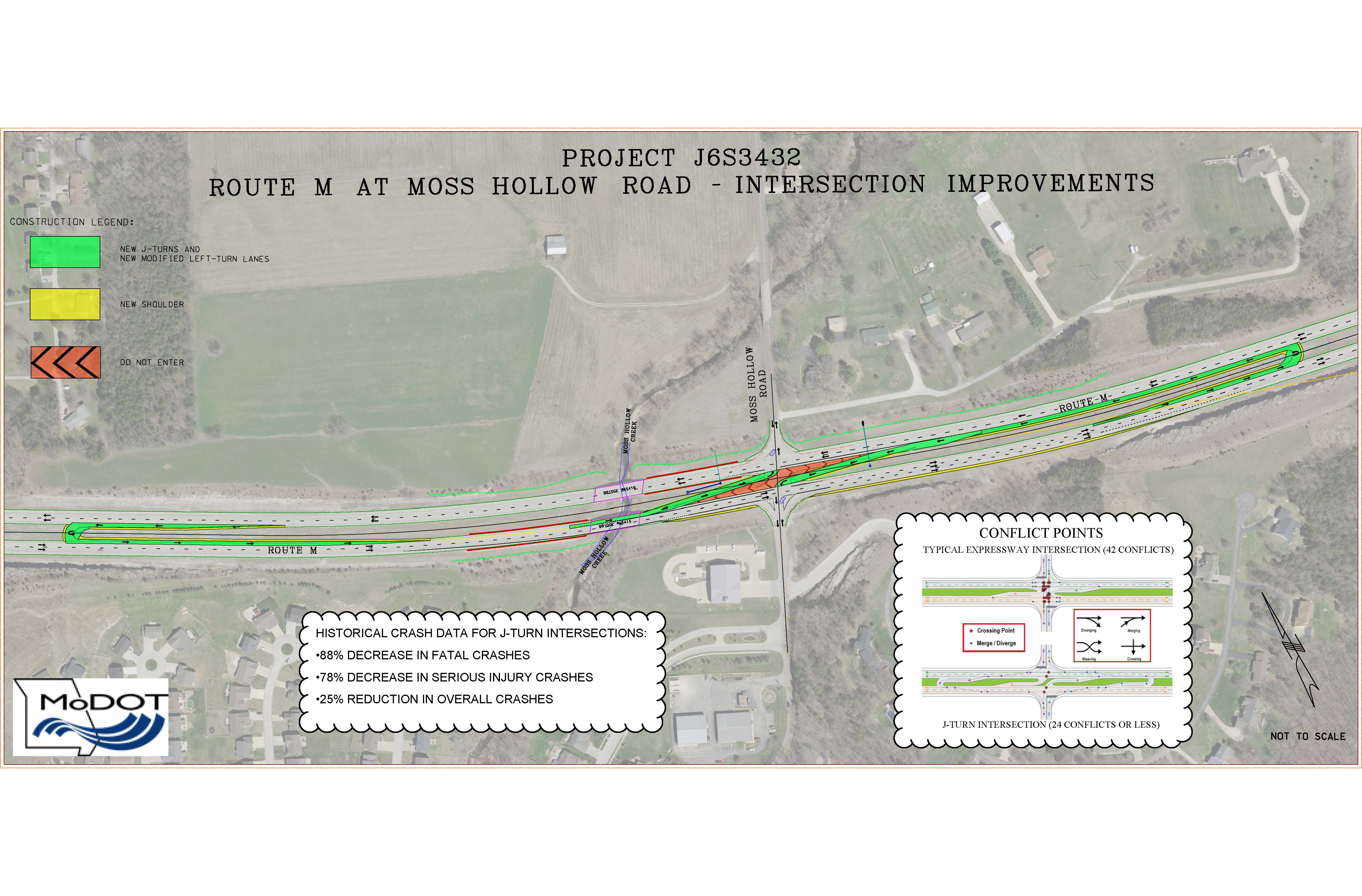
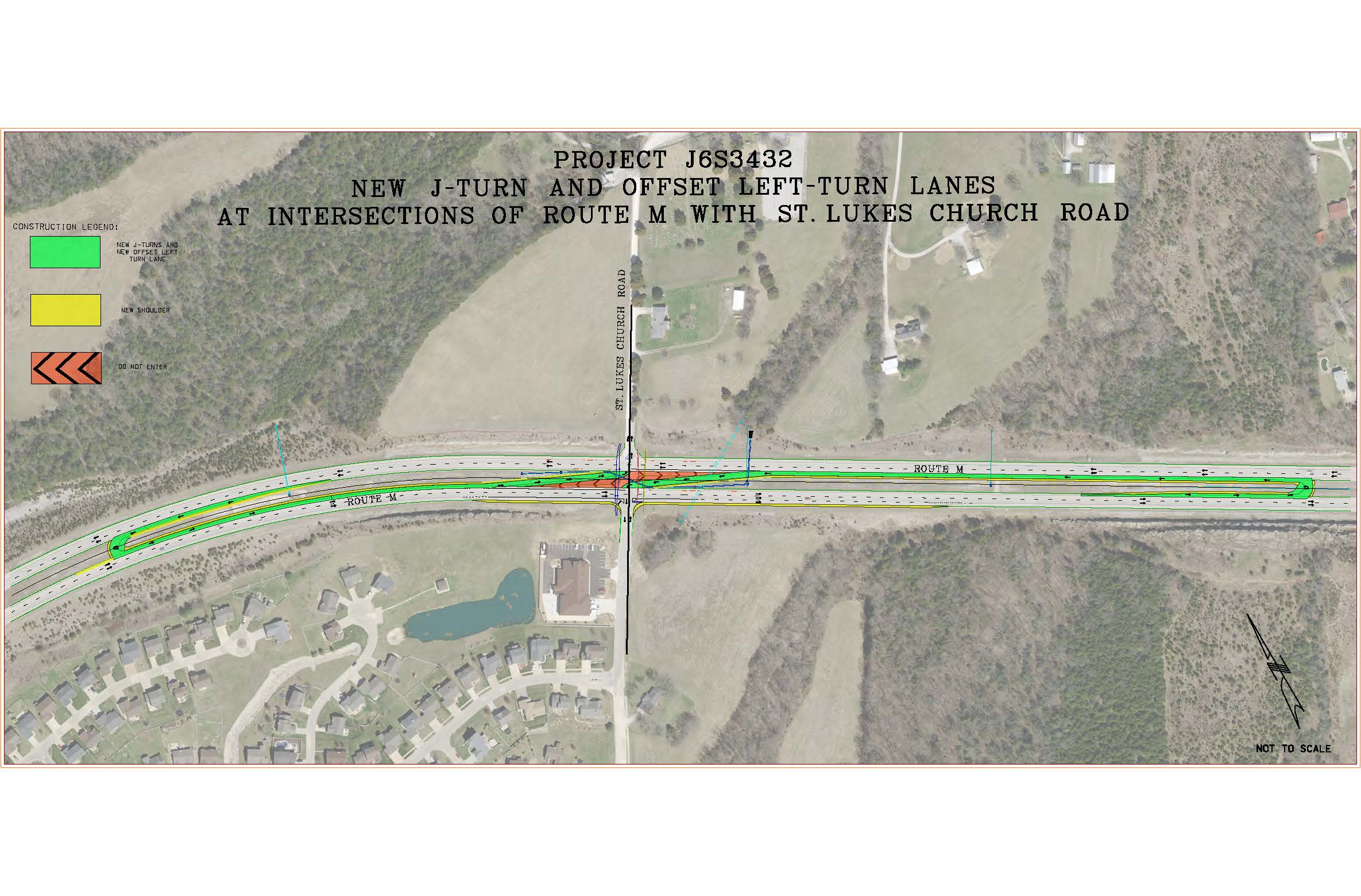
The purpose of this project is to improve safety of the traveling public along Route M, a four-lane divided highway, at the intersections of St. Lukes Church Road and Moss Hollow Road. Based on the intersection’s current design, traffic volumes and motorist frequently speeding along the corridor, serious crash risks are possible as motorists cross the intersections. Approximately 78% of all traffic is traveling above the speed limit.
Most severe crashes are right angle, left turns, and out of control crash types where drivers are failing to yield and/or failing to see oncoming traffic while in the median.
- At Moss Hollow Road, 60% of crashes are angle crashes, 15% are out of control crashes, 10% are left turn crashes and 10% are rear end crashes.
- At St. Lukes Church Road, 75% of crashes are right angle crashes and 25% are left turn-right angle collisions.
A Road Safety Audit (RSA) was conducted for this project. The RSA was performed by a multidisciplinary team, independent of the project, to identify potential safety issues, as well as opportunities for improvements considering all roadway users. The safety strategies evaluated during the RSA included interchanges, roundabouts, signalized intersections, and J-turns.
Based on the research conducted during the RSA, accommodating crossing movements via J-turns and modifying how motorists make left-turns onto Route M from side streets are considered the most cost-effective solutions that will function well into the future, accommodate high traffic volume growths along the corridor and potential increases in intersection turning volumes. Further, modified left-turn lanes better define the intersection and improve the drivers’ ability to see around other vehicles by improving viewing angles.
The following upgrades are being proposed:
- Construct new J-turns and modify how motorists make left-turns onto Route M from side streets
- Add new lighting at J-Turns and at intersections
- Add new signing and striping
Adding these enhancements will improve safety and reduce the number of left-turn, right-angle crashes by more than 80%; as well as reduce the number of all crashes at or near the intersections by 25%. J-turns will eliminate crossing conflict points from 42 to 24 and decrease driver confusion on the median by providing modified left-turn and through movements outside the limits of the intersection. They will also create corridor consistency with the Old Lemay Ferry connector, which has not recorded any crashes associated with the J-turn movements in five-year crash data analyzed.
Additional information on J-turns, as well as a summary of the RSA, are below.
HOW MUCH WILL THIS PROJECT COST?
The cost of construction is estimated at $1.6 million.
Project Timeline
An open-house style public meeting was held on Wednesday, Aug. 31 at the Antonia Fire Protection District, 6633 Moss Hollow Rd., Barnhart, MO 63012.
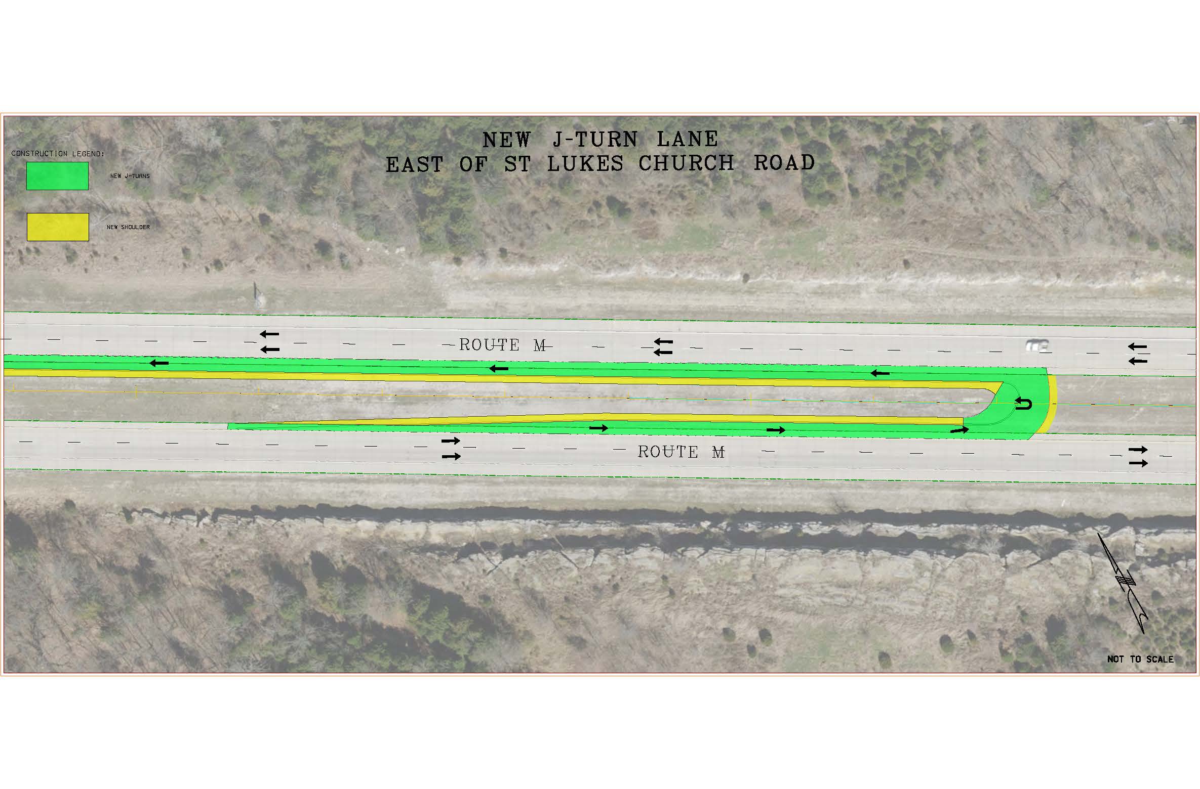
WHAT ARE J-TURNS?
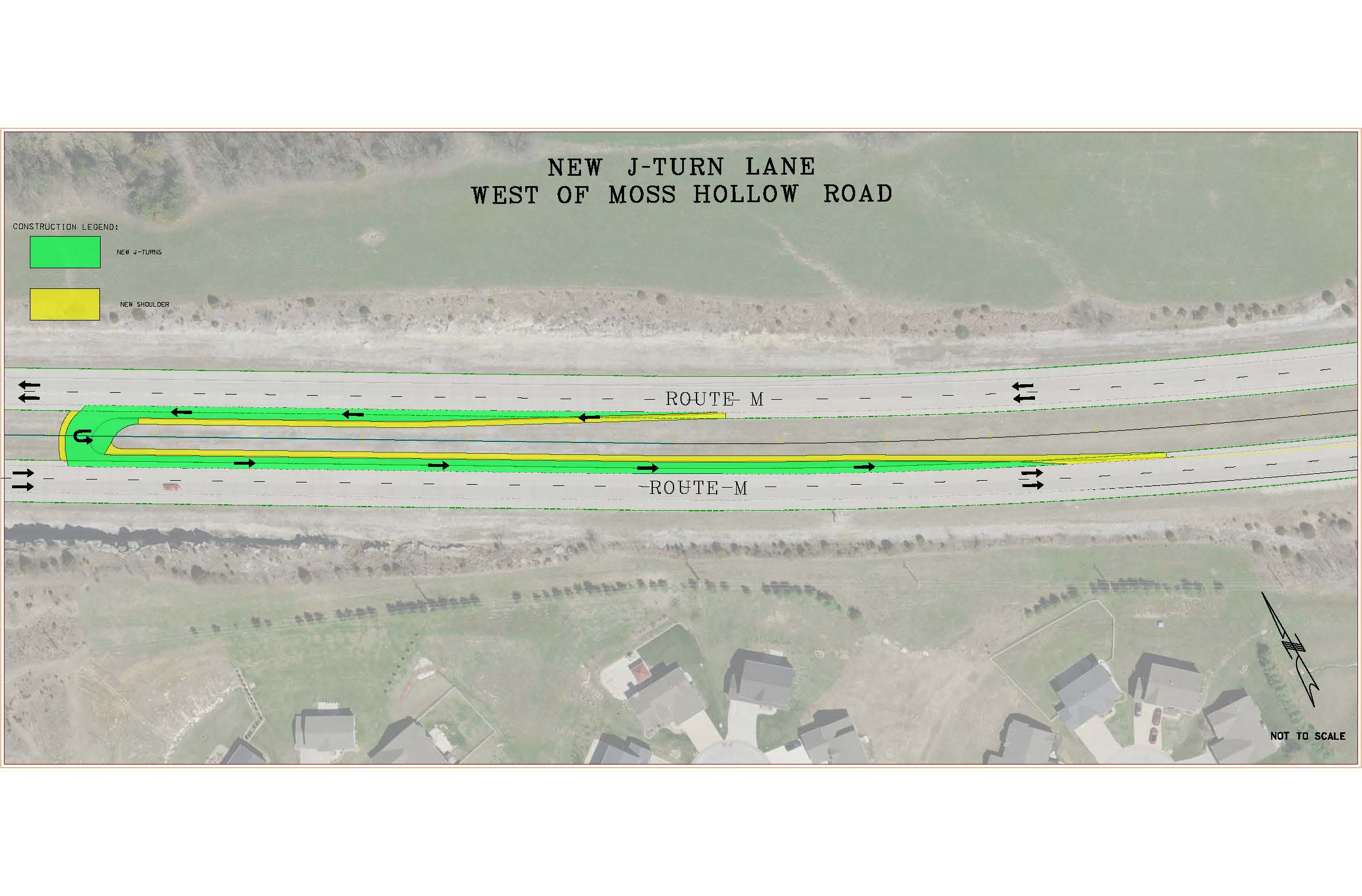
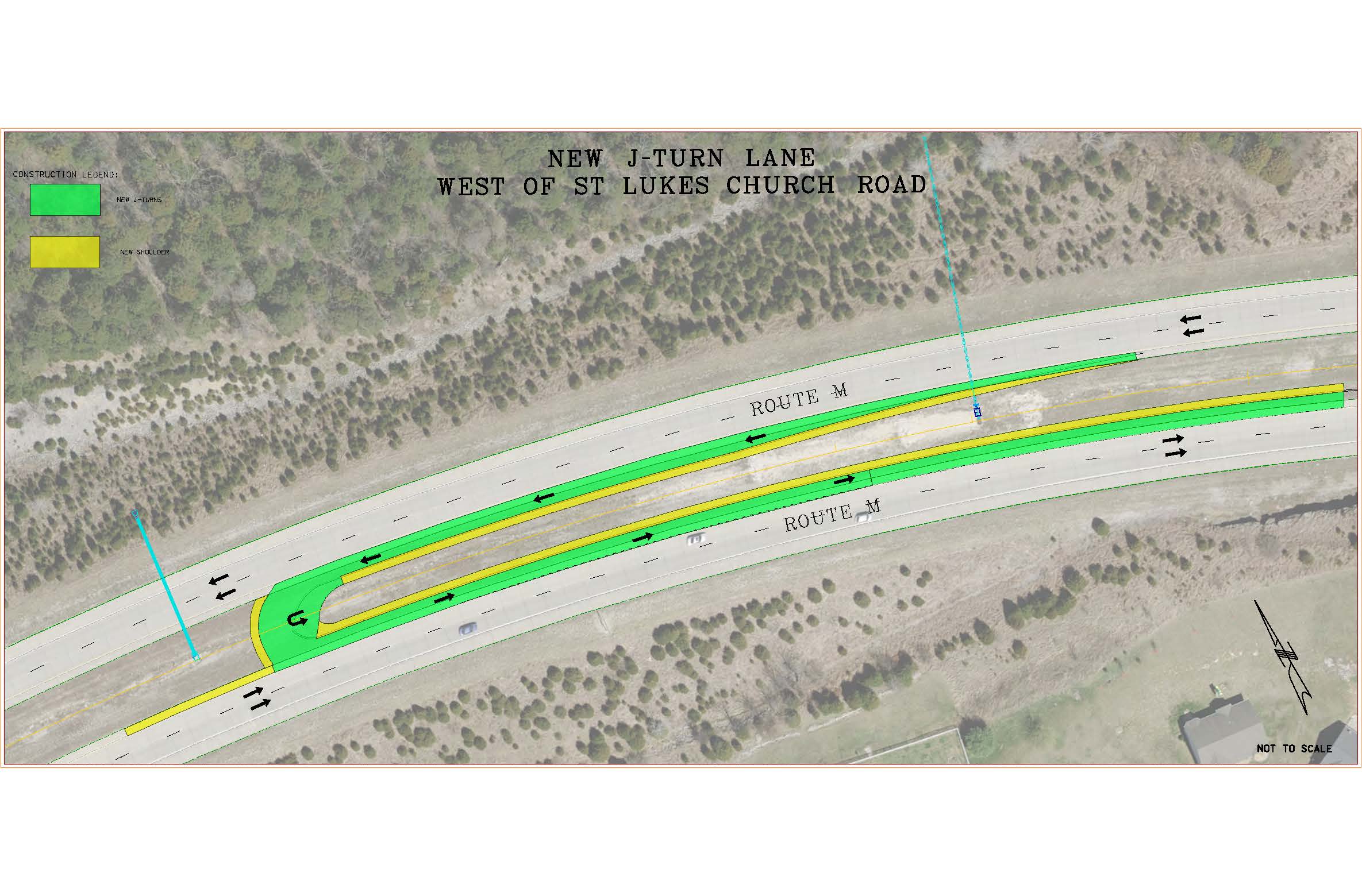
A J-turn is a specialized intersection where, rather than crossing traffic, motorists turn right, merge into the left lane and then make a U-turn at a designated point. J-turns have been proven to greatly reduce right-angle crashes, which are most responsible for fatalities and serious injuries at intersections.
WHY ARE J-TURNS SAFER IN THIS AREA SPECIFICALLY?
Data from J-turns installed on previous projects show a significant reduction in accidents by reducing conflict points at crossovers on high speed throughways. J-turns will eliminate angle crossing conflicts, decrease driver confusion on the median by providing modified left-turns and through movements outside the limits of the intersection and will create corridor consistency with the Old Lemay Ferry Connector, which has not recorded any crashes associated with the J-turn movements in the five-year crash data analyzed. Adding J-turns at these intersections will improve safety by reducing the number of conflict points from 42 to 24 and lowering the possibility for crashes by more than 80%.
WHY ARE TRAFFIC SIGNALS NOT BEING PROPOSED FOR THIS PROJECT?
Traffic signals were one of the strategies evaluated during the RSA. However, traffic signals are not solutions to the crash types experienced at these intersections or given this is a higher-speed route. Traffic signals are installed based on three criteria:
- A high amount of cross street traffic demand
- Crash history
- The delay to turn from the cross street onto the main road
Neither of these intersections meet any of the required criteria mentioned. In short, the use of unwarranted traffic signals on high-speed roads causes excessive delays, disobedience of the signal indications and significant increases in the frequency of collisions (especially rear-end collisions).


Project Contacts
Shirley Norris
Title
Project Manager, Franklin and Jefferson Counties
Department
St. Louis District
Contact Info
Office: (314)-453-5032
Cell: (314)-565-5648
E-mail: Shirley.Norris@modot.mo.gov
Office: (314)-453-5032
Cell: (314)-565-5648
E-mail: Shirley.Norris@modot.mo.gov

Jordan Dalaviras
Title
Area Liaison -- Franklin and Jefferson Counties
Department
St. Louis District
Contact Info
Phone: 314-453-5021
Email: jordan.dalaviras@modot.mo.gov
Phone: 314-453-5021
Email: jordan.dalaviras@modot.mo.gov