The National Park Service and US Fish and Wildlife Service partnered with the Western Transportation Institute MSU to develop a standardized WVC data collection system for federal land management agencies.
Now, through a partnership with the Center for Large Landscape Conservation, this system is available for Citizen Science use in Missouri!
 How to Get the App and Survey Form:
Safety - WARNING: NEVER USE THIS APP WHILE DRIVING. Driving requires your full and cautious attention. To make a report on the app, park in a safe location or have a passenger take your phone and ask them to make the report. Parking on a road can be dangerous. When making a report, always be aware of your safety and surroundings, especially approaching vehicles.
- Go to the App Store or wherever you usually download your apps.
- Search for the free "Survey 123" app and select "GET" for Apple devices and "Install" on Android.
- Once the App has been downloaded, click "continue without signing in" and allow camera access to scan the QR code. Or click and hold the QR code to open Survey123.
- Open the form using Survey123. Please read the training materials for data entry instructions.
- Now you're ready to start collecting data!

Survey123 App Icon

QR Code for ROaDS App

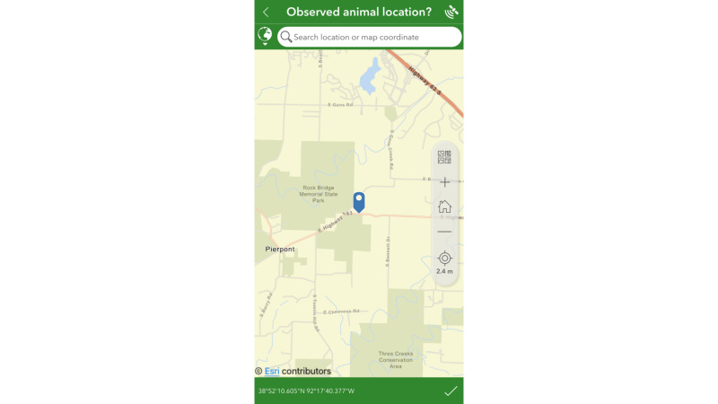
Step 1: Location
- Your location should automatically be shown on the map. You can also adjust this manually if necessary or copy and paste coordinates (latitude and longitude) into the search bar.
- To lock in your location, you MUST click the check mark in the bottom right corner.
- Once the location is locked in, it is saved and you can fill in the rest of the form from a safer location if necessary!
Step 2: Record
*After locking in the location, fill in the rest of the information:
Photo - The photo is optional. Please only take a photo if you are in a safe location!
Type of Animal Observed - Choose from the drop-down list of common species. If you don't see the species you are looking for on the list, you can select "Other" and then will be given space to type in the species. Only one type of animal can be entered at once. If two or more species are seen together you will need to make an additional entry for each species. If you are unable to ID the species you observed, please select “Unknown.
Confidence Level – How positive are you that you’ve correctly identified the species? Sometimes this can be really challenging with roadkill!
Number of Animals - This is just for the one type of species you are making a record for.
Animal Status - REMEMBER, we want to know where animals are approaching/trying to cross the road, as well as where they are getting hit!
Comments - If you are making multiple entries for different species please make a note of that! If you are confident in your identification skills and can accurately identify the animal down to the species level, you can indicate that here as well (Latin or common name is acceptable).
Also, please enter your 3 initials in the comment box so that we can track how many different people have contributed to this effort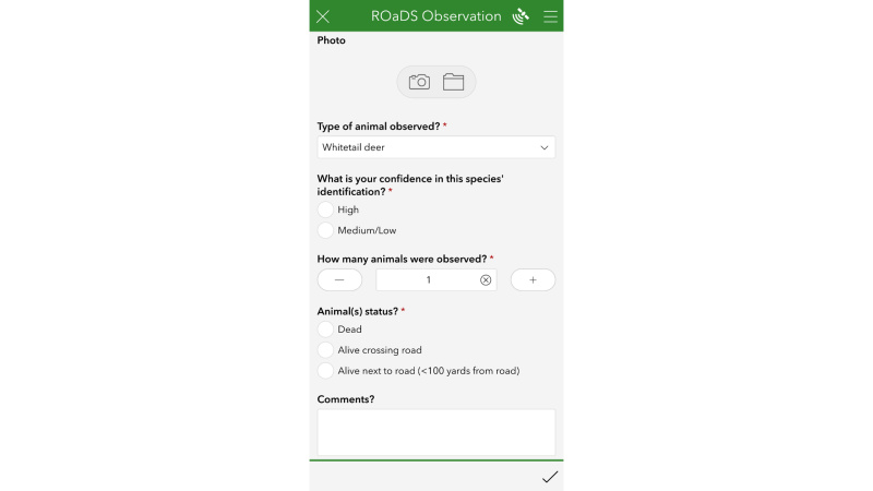
Step 3: View
How to view the data:
All the data collected will be available in real time using our online dashboard!
Use the link provided to see a map and some basic stats on the data that you and other citizens collect.
Please contact Caleb Knerr with any questions at: Caleb.Knerr@modot.mo.gov
If you have sensitive species records you would like to submit, please fill out the Contact WVC Study Team webform with the observation information.
If a roadkill animal is posing a safety concern within the roadway, please call 1-888-ASK-MODOT (275-6636) or contact us to Report a Road Concern | Missouri Department of Transportation online